Maps in the Renaissance World
The fifteenth and sixteenth centuries were an age of discovery and exploration. Some of the most famous of all European explorers flourished then – Christopher Columbus, Vespucci Amerigo, Ferdinand Magellan, John Cabot and his son Sebastian all travelled west in search of the untold wealth (or so they hoped!) of the Indies, and the New World.
Following the explorers, came the conquerors – largely from Spain and Portugal, including such men as Hernan Cortes, Vasco Nunez de Balboa, Alfonso de Albuquerque, Jacques Cartier. By the second half of the sixteenth century, the race was on to control both the Americas and the trade routes to the Indies. Spain, politically linked to Portugal, was the dominant force, but the breakaway Dutch Republic and England began to challenge it, led by the Dutch Sea Beggars and Englishmen such as Drake, Raleigh, Grenville.
Exploration required more and better maps of both land and sea, and the arrival of the printing press allowed these new maps to be disseminated. The mediaeval world had relied on Ptolemy of Alexandria’s Treatise of Geography from around 150 AD (as reconstructed by Byzantine monks in around 1295), the Tabula Rogeriana of Muhammed al-Idris, created for King Roger II, Norman King of Sicily in 1138 and the thousand or so mappae mundi (world maps) that are known to have been created during the period from around 700 AD to the mid-fifteenth century.
In the mid-sixteenth century, there was a huge increase in map-making - new techniques were developed by Gerardus Mercator (1512 – 1594) who created terrestrial and celestial globes as well as charts, and by Abraham Ortelius (1527 – 1598).
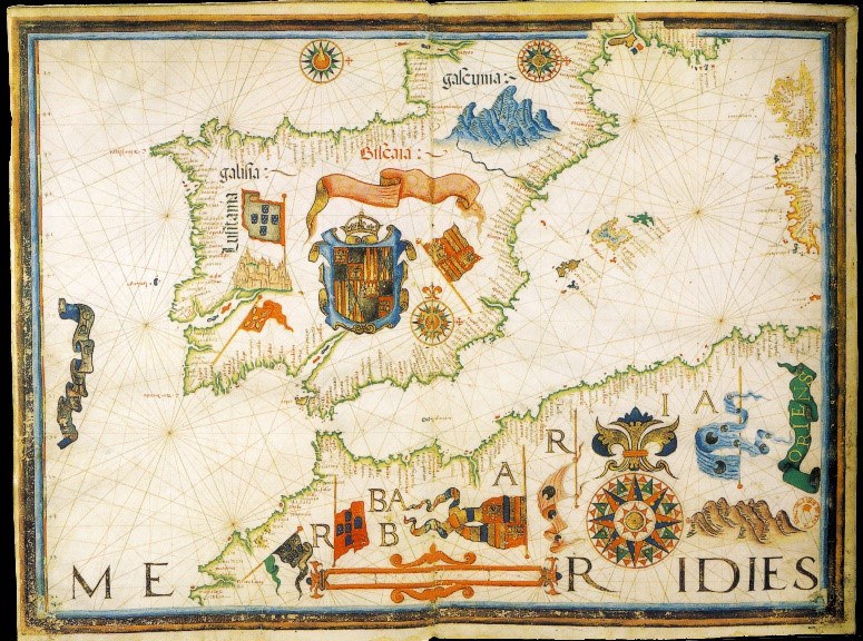
With European states seeking both to centralise and manage their internal affairs more closely, and expand their territories, map-making became something in which governments and rulers took a great interest. In 1555 Mary I of England commissioned a collection of maps for her husband, Philip II of Spain. They were created by the Portuguese cartographer Diogo Homem and consisted of some dozen superb maps of exceptional quality.
Duke Cosimo de’ Medici of Florence, as part of his refurbishment of the Palazzo Vecchio, had a large room dedicated to cartography. The walls of the Sala delle Carte Graphiche are lined with 54 maps 31 drawn by Ignazio Danti and 23 by Stefano Bonsignori, The whole series was completed between 1563 and 1575.
During Elizabeth I’s reign, her Chief Minister, Sir William Cecil, had a particular interest in maps. He had maps by Lawrence Nowell, who mapped the east coast of Ireland and also parts of the mainland of the British Isles. Cecil also had a copy of Ortelius’ Theatrum Orbis Terrarum – considered the first modern atlas, initially published in 1570, and consisting of 53 maps. In 1573, Humphrey Llwyd created the first map of Wales and another of both England and Wales which were published as a supplement to Ortelius’ Theatrum in 1573.
In 1595, Mercator’s great Atlas Sive Cosmographicae Meditationes de Fabrica Mundi et Fabricati Figura was published, dedicated to Elizabeth I of England, and containing some 28 maps, including 16 of Britain, with the remainder being of the poles and the northern European and Baltic States.
But these atlases were all largescale, and concentrated on geographical outlines. What was needed were much smaller scale maps of individual countries, based on detailed surveys. Such an exercise began in 1574 when Christopher Saxton began his survey of Wales, and then England. The full collection (incorporating some of Llwyd’s work) was published in 1579.
Most famous of the British cartographers was John Speed, whose ‘Theatre of the Empire of Great Britain’ was published in 1612. Speed’s maps have been reprinted in a book named ‘Britain’s Tudor Maps – County by County,’ reviewed here.